Hello everyone,
A quick update for you and a correction.
MEETING UPDATE
One more important upcoming meeting that we forgot to mention is tomorrow night at City Hall.
Wednesday, March 29, 2023
Transportation and Public Works Commission Meeting
The agenda can be found here. The meeting will begin at 6:00pm and is in-person only at City Hall. West Cliff Drive Pilot and Neighborhood Traffic Calming is item #2 on the agenda. It is a presentation rather than an action item for the Commission's vote.
A CORRECTION
Our friend, Curt Storlazzi from the USGS, pointed out that something we said wasn’t entirely accurate.
Here are his comments:
In the email you sent out to the community (below), it states,
"For reasons we don’t fully understand, these swells focus their energy on the area between Lighthouse Point and Mitchell’s Cove. This “focusing” is likely related to the bathymetry of the ocean floor in this region."
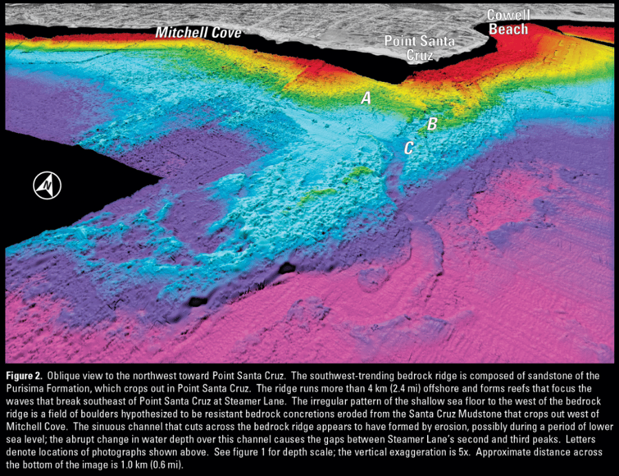
For the record, we absolutely do know why the focusing occurs. Please see this map: https://pubs.usgs.gov/sim/3007/sim3007.pdf that shows the shallower waters ("bathymetric highs") that focus wave energy in this area. The map notes,
"As waves propagate into shallow water, they begin to interact with the sea floor (a process known as "shoaling") and their crests slowly bend to try to maintain their roughly parallel orientation to the bottom contours (known as ”refraction”); wave energy moves perpendicular to the wave crests. In areas where the wave energy converges over the steep, abrupt topography of the bedrock reefs, such as off Point Santa Cruz (fig. 2) and Soquel Point (fig. 4), the waves rapidly slow down, shorten in length, and substantially increase in height relative to the areas on either side of the reefs"
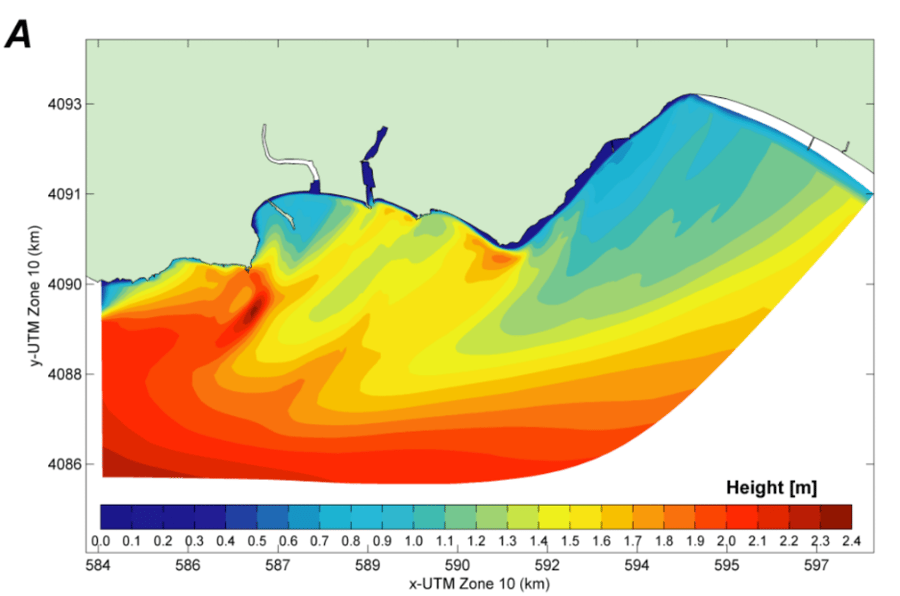
We conducted numerical wave modeling for the Santa Cruz Harbor dredge disposal study. Maps of modeled wave height in Figure 20 (Page 36) and peak-bed shear stresses (force per unit area on the seabed, primarily resulting from ocean waves) in Figure 27 (Page 44) this report: https://pubs.usgs.gov/of/2011/1045/of2011-1045.pdf illustrate that refraction and shoaling over the "Saber Jets" reef with greater wave heights and shear stresses in the are between Woodrow and the Lighthouse.
Please let us know if you have any additional questions about the interactions between the oceanography and geology in this area.
Thank you for allowing us to provide insight into the geophysical processes affecting this area and our town in general.
Curt D. Storlazzi, Ph.D.
U.S. Geological Survey
https://www.usgs.gov/staff-profiles/curt-d-storlazzi
USGS IMAGES
Here is the bathymetry image Curt refers to in Sim3007.pdf:
Here is Figure 20 Curt refers to in of2011-1045.pdf:
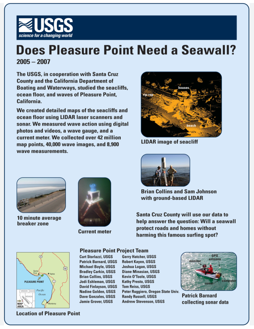
And for those of you who may not be aware, Curt was involved in the Pleasure Point Seawall project on the East Side.
Here is a poster publicizing the work:
And here is a link to the papers from this research:
Storlazzi, C.D., Barnard, P.L., Collins, B.D., Finlayson, D.P., Golden, N.E., Hatcher, G.A., Kayen, R.E., and Ruggiero, P., 2007. “High-Resolution Topographic, Bathymetric and Oceanographic Data for the Pleasure Point Area, Santa Cruz County, California: 2005-2007” U.S. Geological Survey Open-File Report 2007-1270, 23 p. http://pubs.usgs.gov/of/2007/1270/
and
Storlazzi, C.D., Golden, N.E., and Finlayson, D.P., 2008. “Views of the Seafloor in Northern Monterey Bay, California” USGS Scientific Investigations Map 3007, 1 p. http://pubs.usgs.gov/sim/3007/
We are very fortunate to have scientists like Curt in our community, and we thank them for keeping us factual!
Thanks again,
Save West Cliff
#savewestcliff